File:Cyprus2022OSM.png
Jump to navigation
Jump to search
Original file (4,212 × 2,750 pixels, file size: 2.67 MB, MIME type: image/png)
Summary
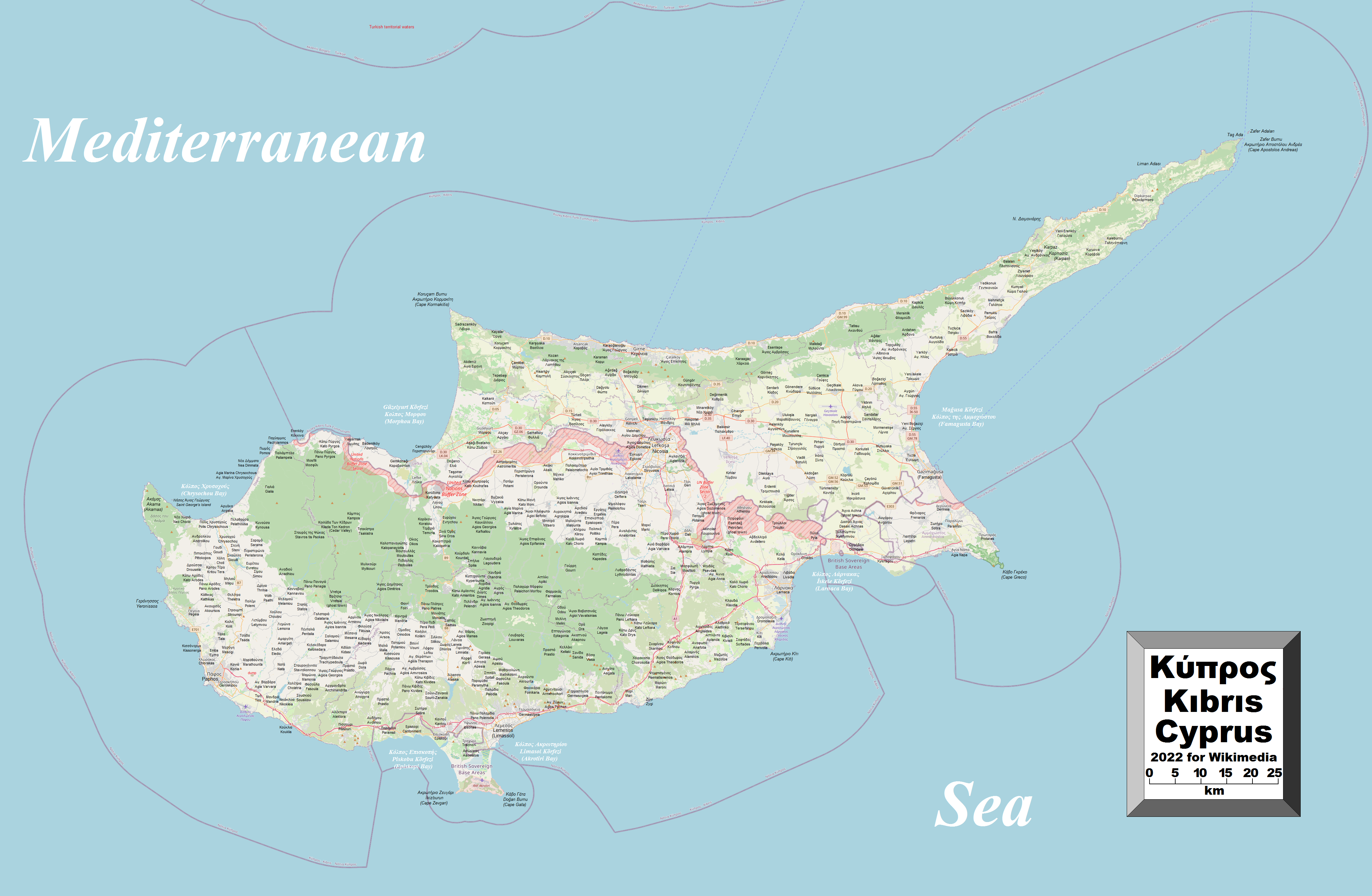
| Description |
English: This map of Cyprus shows the country's cities, towns, villages and some other geographical details, and is likely the most comprehensive map of the country in this respect that you'll find anywhere online. It has been stitched together from panels of Open Street Map (which is freely licensed to all) with details plotted by the uploader, among which are a great number of inhabited places (and even the odd uninhabited place), the British Sovereign Base Areas, the United Nations Buffer Zone along with the Green Line (shown, however, in red and purple, respectively), coastal features and a few other things (see if you can spot the word "dump" on the map). A lack of room made it impossible to include all the information that users might like to see. To avoid having too much clutter on the map, places in the self-declared republic in the north are given their Turkish names with their Greek names underneath (without Latin-script transliteration), while places still under the southern republic's administration are given their Greek names with Latin-script transliterations underneath (finding their Turkish names was a bit of a problem). In a very few cases, English names (if different) are also given. Also, not absolutely every village has been included. |
| Date | |
| Source | Own work |
| Author | Kelisi |
| Permission (Reusing this file) |
The aforesaid website is freely usable to all. |
Licensing
I, the copyright holder of this work, hereby publish it under the following license:
This file is licensed under the Creative Commons Attribution-Share Alike 4.0 International license.
- You are free:
- to share – to copy, distribute and transmit the work
- to remix – to adapt the work
- Under the following conditions:
- attribution – You must give appropriate credit, provide a link to the license, and indicate if changes were made. You may do so in any reasonable manner, but not in any way that suggests the licensor endorses you or your use.
- share alike – If you remix, transform, or build upon the material, you must distribute your contributions under the same or compatible license as the original.
File history
Click on a date/time to view the file as it appeared at that time.
| Date/Time | Thumbnail | Dimensions | User | Comment | |
|---|---|---|---|---|---|
| current | 20:46, 21 May 2022 | No thumbnail | 4,212 × 2,750 (2.67 MB) | commonswiki>Kelisi | Uploaded own work with UploadWizard |
File usage
The following page uses this file: